|

|
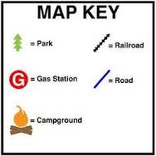
Map Key
Maps can be drawn to represent a variety of information. This information might include things such as roads, tourist attractions and campgrounds, or they might represent the latest weather patterns. The objects on a map are represented using symbols. A symbol is a picture on the map that represents something in the real world. Understanding these symbols requires the use of a key. Maps use a key, or legend, to explain the meaning of each of the symbols used in the map. These keys usually show a small picture of each of the symbols used on the map, along with a written description of the meaning of each of these symbols.
Map Scale
Remember that a map is a picture of a much larger area of land. In order to be useful, a map must be small enough to be handled by a person. Imagine drawing a map of the Earth that was full-size. A full-size map of the Earth would not only be too large to hold or look at, but it would also be difficult to make. Maps are scaled down so that they fit on the available paper or screen. When scaling down a map, every part of the map is scaled by the same amount. This insures that every object on the map is the same proportion as everything else on the map. If a city is twice as large as a neighboring town, an accurate scaled map will show the same relationship on paper. The drawn city will be twice as large as the drawn town.
